|
Home >>
Hill Stations in Himachal >>
Sangla
|
Sangla |
Facts & Figures of Sangla
Location - Himachal Pradesh
Altitude - 8900 ft.
Best Time - July to September.
|

|
Sangla Valley is situated at an altitude of 8,900 ft and constitutes the part of district of Kinnaur. It is at a distance of 238 km from Shimla. Sangla is lies on the right bank of Baspa River, which is 17 km from Karcham.
Sightseeing Highlights :
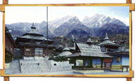
One of the major attractions close to Sangla is the Kamru Fort, which has now been turned into a temple dedicated to Kamakshi Devi. An image of the goddess is installed on the third floor of this structure, while a large statue of Lord Buddha stands guard at the temple-fort's main gate. Also nearby is a Buddhist Monastry and the Bering Nag Temple, which honors the God Jagas. The Fulaich fair, a much loved, colorful affair, is celebrated here every year between August and September, and attracts hundreds of visitors. |

|
Another popular stop in Sangla is the Trout Farm, which has been set up by the state's Fisheries Department. Well stocked with trouts, it attracts numerous fishing enthusiasts. A Saffron Farm, situated on the outskirts of Sangla, and a Tibetan Wood Carving Centre are also worth visiting. |
|
Other Activities :
The area offers abundant opportunities for scenic long walks and treks. One of the most popular, and relatively easy, treks here is the one which starts from Sangla, passes through the charming villages of Kamru and Rakcham before reaching Chitkul. This pretty little village, around 20 km from Sangla, is a wonderful place for seeing the simple life of the people of this region, and also serves as a base for those heading for the Kinner-Kailash trek.
There are also several pine nut, cherry trees, Royal red apple and chilgoza orchards that are delightful to walk through, as are the neighboring forests and wooded areas. Adventure lovers can also opt for the many camping and paragliding facilities available in Sangla.
Located a short distance from the Tibetan border, Sangla is a small town in the Baspa Valley, which is also known as the Sangla Valley. The mighty Himalayas and the Kinner-Kailash peak tower over this picturesque town, which is set at a height of nearly 2,700 m, on the banks of the fast flowing waters of the Baspa River.
Set amidst fruit orchards and thickly forested slopes that are covered with pine and deodar trees, Sangla is widely acknowledged as one of the most beautiful valleys in the world. In the Tibetan language, the word sang actually means -light- and la means 'pass'. As such, the word Sangla stands for 'pass of light', as on crossing the majestic mountains, one suddenly emerges into a valley filled with bright sunshine and breathtaking natural beauty.
How to Reach
By Air : Tne nearest airport to Sangla is at Shimla, 238 km away and Chandigarh.
By Rail : The nearest railway stations are at Shimla, Kalka and Shoghi.
By Road : Sangla valley is well connected by surface network with major towns like Shimla, Narkanda, kalka, Ambala, Chandigarh and New Delhi. |
| |
|